Long Distance Trails – Paulins Kill Valley Trail


NEW YORK/PHILADELPHIA METROPOLITAN AREA
OPEN SPACE RESOURCE LIBRARY
Paulins Kill Valley Trail
Managed by NJ Dept. of Parks and Forests, NJ Dept. of Fish, Game and Wildlife
Map: http://www.traillink.com/trail/paulinskill-valley-trail.aspx
Map: (Columbia Lake section) http://www.nj.gov/dep/fgw/pdf/wmamaps/columbia.pdf
This trail is about thirty miles long, following the former route of the New York, Susquehanna, and Western Railroad mostly from Columbia to Sparta Junction. The section from Columbia to Warbasse is also the route of the Liberty-Water Gap Trail. Beginning at the Portland-Columbia Foot bridge, site of the last covered bridge to span the Delaware (destroyed in 1955), the trail follows along Rt 46 south, here just a small concrete street. It turns right and descends to the confluence of the Paulins Kill with the Delaware River and turns left under the highway on a new concrete walkway (floods during high water). The trail then ascends on the other side of the bridge and uses the pedestrian walkway to cross the Paulins Kill. Once on the other side, it soon turns left to the original right of way of the Blairstown Railroad (1876). This line turned south to join the Warren Railroad in Delaware. It became part of the NYS&W in 1881, and it was extended to Stroudsburg and Jersey City. Rt 46 has obliterated most of the southern route of this line, although a section of cut is visible in Delaware. The trail follows a path along a yard, and then parallel with the railroad fill before climbing to join it near the Columbia Lake dam. The rail bed is then a gravel access road out to Warrington Road.
The status of the trail from Warrington Road to Hainesburg is currently questionable. From Warrington Road to Bruglar Road, it is very overgrown and difficult to walk. A right turn on Warrington, followed by a left on Bruglar is not a difficult bypass. However, at Bruglar Road, a private land owner has gated the rail bed for a short distance. State park signs resume a short distance beyond. There are currently negotiations going on regarding this site.
Just beyond, the trail becomes very wet, but dries before the former site of Hainesburg Junction, where the Lehigh and New England Railroad joined and had trackage rights over the NYS&W for about twenty miles to Swartswood Junction. Continuing northeast, the trail passes beneath the Paulins Kill Viaduct, one of the largest concrete bridges in the world, and then beyond through the villages of Vail, Kalarama, around the Blairstown Airport, and to the town of Blairstown. A foot bridge leads across the Paulins Kill from here to businesses.
North of Blairstown, the trail passes through Paulina, followed by Marksboro where the Ridge and Valley Trail departs. It then continues on through Stillwater, Swartswood, Warbasse where it crosses Sussex Branch Trail, and finally Sparta Junction. After crossing Rt 623, the trail is less maintained and crosses two less decked bridges over small creeks. This section is not as well suited for bicycles or horses. It dead ends at the former site of Sparta Junction. The NYS&W continued straight across the former Lehigh and Hudson River Railroad (also a trail south of here). The NYS&W remains active east of here.
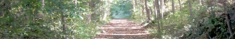
This trail has fantastic scenery ranging from deep woods, little towns, and lovely riversides. It crosses the Paulins Kill River four times on decked bridges, and several other smaller tributaries. It passes through deep cuts and along rocky shelves showcasing the ridges and valleys of northern NJ without the difficulty of a rugged mountain hike.
Trail:
0.00 Beginning of trail. Portland-Columbia Foot Bridge. Head south along the concrete paved old Rt 46. The right edge of the road is striped with pedestrian logos for the trail. The Liberty Water Gap Trail, with it's current terminus on the PA side of the foot bridge, follows the PKV Trail from here to Warbasse Junction.
0.27 Pass beneath the Portland-Columbia toll bridge
0.37 Where the highways merge, the trail follows a crushed stone path off to the right of the highway, and begins to descend to the confluence of the Paulins Kill River with the Delaware.
0.44 The trail becomes a concrete sidewalk. The reason for this is because the Paulins Kill will occasionally flood above the level of the trail. Turn left and pass beneath Rt 46. The trail passes by the ruins of an old dam in Columbia Lake Wildlife Management Area, and then ascends back to the highway on the other side.
0.50 Cross the Paulins Kill using the pedestrian walkway along Rt 46.
0.60 After passing a driveway entrance on the left, the trail also turns left away from Rt 46 at an opening. This opening is not posted with any signs, so it is easy to miss. It crosses over a small mound and skirts the edge of a private yard. The trail now follows the original 1876 right of way of the Blairstown Railroad. At the end of the yard, the trail turns off of the rail bed and continues along a cleared path below the fill of the rail line to the right. This is part of Columbia Lake Wildlife Management Area.
0.80 The trail reaches a former quarried out spot and climbs to the left to rejoin the railroad bed. Perhaps the lower route used by the trail was once a quarry siding.
0.85 Reach the Columbia Lake dam on the left. From here to Warrington Road the trail is sometimes used as a fisherman's access, so vehicles may be encountered. The trail has a gravel surface and continues along the shore of Columbia Lake.
1.15 The trail passes through a giant pipe under Rt 80. It deviates from the rail bed here briefly due to the construction of the superhighway. This is also the site of a former junction. When New York, Susquehanna, and Western Railroad took over the Blairstown Railroad in 1881, the line was extended north to East Stroudsburg (and later to Wilkes Barre). The former junction site where the northbound NYS&W has been obscured by Rt 80, but it crossed Columbia Lake at roughly the same place. After passing through the pipe, continue as the trail regains the railroad bed with nice views of Columbia Lake.
1.60 The trail begins to turn away from Columbia Lake.
1.85 Reach Warrington Road at a small bridge over a tributary. The right of way across Warrington Road is badly overgrown, and is sometimes posted. Although most of the trail has been deemed a linear greenway, this area is the only part where any dispute remains. For the purposes of this guide, the mileage will continue on the railroad right of way, but hikers may wish to turn right on Warrington Road, then left on Bruglar. The difference in distance at this point is insignificant.
2.05 The rail bed comes out of obscurity to the left and Bruglar Road has been widened across it. Ahead, Bruglar Road turns left and crosses the Paulins Kill on a beautiful stone arch bridge, while the rail bed continues ahead. There was once a state park gate here, but it was removed. A private gate has been installed over the rail bed, although state park signs resume a very short distance away where the driveway turns. There are reportedly negotiations to formally open this section, but in the meantime this part may be private property.
2.15 State park signage resumes where the rail bed turns away from the private drive. The rail bed is very muddy and unpleasant in this section, but gets much nicer after a short while.
2.75 Reach the former site of Hainesburg Junction. Here, the Lehigh and New England Railroad had trackage rights over the NYS&W to Swartswood Junction. To the west, the L&NE line runs through private property, please do not trespass. It reaches the intersection of Bruglar Road and Rt 94 after crossing an old through style truss bridge. From Rt 94 to Columbia it is being developed as a rail trail (See Knowlton Trail). A pile of rubble between the two rights of way is all that remains of the telegraph office. Another building, also in bad shape was across the L&NE rail bed. The Paulins Kill Valley Trail continues ahead much clearer. A side trail breaks off to the left and leads to beneath the Paulins Kill Viaduct to make a short loop.
3.15 Reach Station Road and the Paulins Kill Viaduct. This seven arch concrete span was modeled after the aqueducts of Rome. At the time of it's completion, it was the largest concrete structure in the world. It still ranks among the top ten. The bridge carries the Lackawanna Cutoff, considered to be the largest cut and fill project in human history. The Cutoff was the largest of many improvements made to the Lackawanna Railroad in the earliest days of the 20th Century. This section opened by 1911. The trail continues parallel with Station Road to the left.
3.20 Pass the foundation of the former Hainesburg Station to the left of the trail, which can be somewhat overgrown. Many miss this point because they choose to walk the easier Station Road. The trail soon comes out to Station Road. Continue ahead, and the rail right of way becomes visible on the right side and can be walked.
3.45 Station Road turns right and crosses two old truss bridges over the Paulins Kill. PKV Trail continues ahead past a gate into the woods. The trail ahead runs fairly close to the Paulins Kill and is quite pretty.
4.15 The Paulins Kill turns dramatically to the left, out of view from the rail bed.
4.35 Pass beneath utility lines and a farm crossing, with very nice views to the north of the Kittatinny Ridge.
4.50 Closely parallel Kill Road shortly after crossing a little bridge over a tributary.
4.75 Cross Crisman Road. There is an intersection to the right of the crossing with Polkville Road.
5.12 Cross a farm lane. The trail continues through lovely pastoral setting.
5.80 Reach Vail Road in the village of Vail. There was once a station and creamery here.
5.23 After passing over a fill, cross Gwinup Road. A driveway closely parallels the rail bed for a short section. Notice the old whistle markers along the trail, which signaled the trails to alert their approach to a grade crossing. Continue through more farm land.
6.80 Reach Blairstown Airport (formerly Kalarama Airport). The airport has partially been constructed over the railroad bed, so it is necessary to skirt the outside of it. The outline of the Delaware Water Gap can be seen from the airport road.
6.95 A side path leads to a former recreation area along the shore of Lake Susquehanna. There is an abandoned restroom there, as well as an abandoned swimming beach.
7.10 Pass an abandoned building on the right. Although the house looks rather new in construction, it is actually a 19th century dwelling with modern additions and replaced roof. It is unsafe and in poor condition. Continue along the airport road.
7.30 Reach Lambert Road and turn left. The rail bed is now part of the runway system of the airport. This was once the site of Kalarama Station. An attempt was made by NYS&W to move the station to Vail in 1891, but it fell off of the train that carried it and was destroyed.
7.50 The trail resumes on the rail bed; turn right off of Lambert Road.
7.75 The rail bed follows a shelf where there are ball fields visible to the left, part of North Warren Regional High School.
8.40 Cross a farm lane with some nice pastoral views.
8.95 Another farm crossing. The rail bed and trail widen just ahead. A second trail was once in place on the approach to Blairstown Station.
9.40 Former site of Blairstown Station, now Footbridge Park. This is a large parking area with a picnic pavilion. The foot bridge for which the park takes it's name is worth the side trip. It crosses not only the Paulins Kill, but the entire flood plain, making it passable during even flood conditions. It leads to Rt 94 in Blairstown where food can be purchased at the Blairstown Diner or Dale's Market close by.
Many buildings once stood at Footbridge Park, the original terminus of the Blairstown Railroad until it was extended in 1881. The buildings were razed by the town in favor of the park in 1976.
9.60 The trail reaches Rt 94 underpass after paralleling the access road to Footbridge Park. More parking is available near the underpass. The trail parallels Rt 94 for a bit, but below and out of sight.
10.18 Cross the Paulins Kill on a girder bridge that has been redecked.
10.33 Cross East Crisman Road in the village of Paulina. This is one of the loveliest mill and dam sites in Warren county. A through style truss bridge and a stone arch carry the road over the Paulins Kill, where there are good views of the dam. A side trail breaks away from the PKV Trail ahead where better views of the slack-water lake are possible. The trail then descends, returning to the rail bed.
10.50 The trail follows closely to the water's edge on the right
10.75 Pass through a girder style bridge over the slack water Paulins Kill. Lovely views of the lake.
11.40 Cross the Paulins Kill again on a deck girder bridge. Ahead, the trail comes close to private lands, many of whom are not friendly to hikers. Signage forbids anyone from even "looking" at their land.
12.60 Cross Spring Valley Road in Marksboro at a nice parking area. This is also the beginning of the Ridge and Valley Trail's main route. It's trail markers begin only 0.1 mile up hill on Spring Valley Road where it follows a former spur line of the NYS&W. This trail will, when complete, connect Paulins Kill Valley Trail with the Appalachian Trail.
12.65 Former junction site with the White Lake spur track. Foundations remain from former buildings.
13.30 The trail crosses the Paulins Kill yet again, this time on the most attractve of it's bridges. This through style truss bridge was embellished with curving steel to make for a more aesthetically pleasing look.
14.37 After a driveway parallels for a short distance, cross Stillwater road. The trail parallels a field to the right ahead, after a section of woods.
14.80 Cross Henfoot Road. The trail continues across a well manicured private lawn. Please stay on the trail.
14.88 The trail crosses a small tributary in the open lawn area. Several side trails turn right and parallel the stream on private land.
15.55 After a long section of woods, a field opens up on a surprisingly steep slope to the right. Notice a large outcropping rock in the middle of the field. Horses can often be seen here. It resembles a scene from the American old west.
16.00 The trail follows a farm pond on the left.
16.13 The trail crosses Cedar Ridge Road. Ahead, it has been very badly washed out for several hundred feet.
16.70 Cross East Stillwater Road
17.05 Cross Stillwater Station Road. No sign of the former station remains. The historic village of Stillwater is to the left, which has many old buildings including a Grist Mill.
17.34 Pass beneath utility lines
17.68 Reach Rt 610. The trail climbs a gradual grade to cross the road, which would have at one time been an underpass. Just beyond the road, pass the ruins of an old creamery on the right.
18.45 Cross Kohlbocker Road on a diagonal after paralleling it for a bit. The trail continues to parallel it ahead.
18.80 A path leads down the left side of the rail bed to Kohlbocker Road. Turn here; the bridge ahead over Rt 614 is out. Follow Kohlbocker Road, and turn left on Rt 614, then right onto South Shore Terrace. Pass near the dam for Paulins Kill Lake and parallel the waterfront.
19.00 A path leads back up to the railroad grade. Continue. The rail bed parallels the road for a bit, as well as Paulins Kill Lake. The rail bed is mostly on a high shelf, but occasionally goes through a dramatic cut with informal side paths climbing the walls, then descending back to the rail bed.
20.25 The trail begins to turn away from Paulins Kill Lake. Soon pass Summer cottages on the left.
21.10 Pass by the foundation of Swartswood Station in this area.
21.20 The trail turns away from the rail bed and gradually descends on abandoned Station Road to Newton-Swartswood Road. Staying on the rail bed would lead to another missing bridge, but also a section of restored track and an abandoned water tower ruin. After crossing Newton-Swartswood Road, climb the embankment on a path and continue on the rail bed. Parallel Junction Road.
21.50 Close to the former site of Swartswood Junction. Shortly after passing a pile of rubble to the right, the former telegraph office, the Lehigh and New England Railroad diverged to the left. This rail line is currently under development as a new rail trail, under jurisdiction of Kittatinny Valley State Park. A 13 mile loop using the PKV Trail, Sussex Branch, and LNE Trail will be possible from here.
22.15 Cross Plotts Road. The LNE grade to the north is now out of sight. It crosses Parson Road atop a nice culvert. Continue ahead parallel with Spirol Road. This road appears to be abandoned.
23.15 Cross a private lane.
23.60 Cross a utility line. Ahead, the trail passes through the most dramatic cut on the entire trail.
24.00 Parallel Halsey Road
24.10 Cross Old Halsey-Myrtle Grove Road on a diagonal. There is a pen on the right side before the crossing with a pony. Beware! This pony bites those who try to pet it!
24.25 Cross Rt 519. Continue to parallel Halsey Road for a bit. The trail then turns away to more pastoral settings again.
25.20 Cross Rt 206 with caution, beside a small parking lot for businesses. There was once a pizza place here, but it has closed. The trail enters woods on the other side near the intersection with Sid Taylor Road.
25.55 Farm crossing, homes visible to the north.
25.85 Cross Rt 94 after closely paralleling Sid Taylor Road. This requires descending to road level. Apparently there was once a bridge here.
26.63 The trail crosses a farm lane and continues into woods.
27.05 Reach Warbasse Junction road where there is good parking. Cross and continue.
27.10 Warbasse Junction. Once the junction between the Sussex Branch of the Delaware, Lackawanna, and Western, it is now the junction of two substantial trails. The Sussex Branch continues north to Branchville, and south to International Trade Center in Mount Olive. The Liberty-Water Gap Trail leaves the PKV Trail here, and follows the Sussex Branch Trail south on it's way to Liberty State Park.
27.30 The PKV Trail crosses the abandoned right of way of the DL&W Railroad's Franklin Branch (1869-1934). Just ahead, PKV Trail crosses a small stream on a bridge. The Franklin Branch crosses the same stream, but only the concrete abutments of the bridge remain. A swamp separates the two rights of way to Garrison Road.
27.72 Cross Garrison Road. The rail bed ahead is not maintained like the rest of the trail. Immediately cross a barely decked bridge over a tributary. Continue to skirt wetlands.
28.48 Reach Rt 623. The PKV Trail crosses. The Franklin Branch also turns from near a private home on the road's bend. It would make an excellent trail. Much of it is clear, but not open to public.
29.00 Cross Another tributary on another less than perfect bridge.
29.20 The trail pretty much disappears here. ATV activity is apparent, and the area to the left of the right of way is very disturbed.
29.30 Sparta Junction. The trail ends at the active tracks. It was here that the NYS&W crossed the Lehigh and Hudson River Railroad. To the south of here, some of the LHR is on public land, abandoned in 1986, but to the north it is operated by NYS&W (that's right, the name is still used!) well into NY state.
The route of the former NYS&W eastbound remains active, through the beautiful landscape of Sussex and Passaic county on it's way to Jersey City. Do not trespass on active tracks.

Hosting courtesy of Firebrand Communications. Website design by SGF Studios
©2012 Metrotrails unless otherwise noted • All rights reserved